

Seattle’s Forecast for Another Hot Summer
In 2017, Seattle’s rainfall was over 10 in. above average, and we broke a 122 year old record for the wettest winter-spring season (Oct-April)*. This was followed by 55 days without rain, breaking another record.
Earlier snow melting and drier summers will have significant consequences for our Northwest ecosystem, including impacts on fish populations and increased risk of wildfires. Our home comfort will be affected too. The historically gentle temperature range, punctuated by a few days of heat and a few of freeze, will continue to move toward more extremes. This puts greater demands on our houses for proper and sufficient ventilation, and equipment to keep us comfortable.
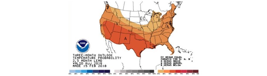
NOAA’s Summer 2018 Forecast
The big swings in rainy and dry conditions in the Northwest are expected to continue. The current forecast for spring shows below normal temperatures through this month (May) with normal precipitation, switching over to drier and hotter than average this summer. NOAA (The National Oceanic and Atmospheric Administration) provides the country’s official weather forecasting. Their summer forecast map below shows a 50% chance of above normal heat this summer. They also forecast precipitation significantly below average this summer.
- 2016
- AC
- AC Installation
- AC Units
- AFUE
- air conditioing
- air conditioner
- air conditioning
- air conditioning maintenance
- air conditioning service
- air conditioning tune-up
- air duct
- air duct cleaning
- air handlers
- air pollution
- Air Purification System
- air purifier
- Air Sealing
- angie's list
- award
- basement Finishing
- Bathroom remodel
- BBB
- BBB Accredited Business
- before and after
- Best air conditioner
- best filters
- best generator
- best locks
- best water heater
- best window install
- boilers
- bryant
- Bryant AC
- bryant furnace
- bryant heat pump
- christmas lights
- clean air
- clothes drive
- Clothes For Kids
- coat drive
- combi-boiler
- comfort
- community
- Construction
- contractor
- contractors
- Cooling
- Cooling equipment
- Coronavirus Protection
- custom
- daikin
- deals
- discounts
- DIY
- Donation
- Donations
- door hardware
- door installation
- door replacement
- Door Transformations
- doors
- drafty home
- drain cleaning
- Duct Cleaning
- Duct Cleaning Services
- ductless
- Ductless heat pump
- ductless heat pump. mini-split
- Ductless heat pumps
- ductless heating system
- ductless heating systems
- ductless installation
- Ducts
- earth day
- eco friendly
- EER
- election
- electrical inspection
- emergency
- energy
- energy conservation
- energy efficiency
- energy efficiency rebates
- energy efficient AC
- energy efficient air conditioner
- energy efficient home
- energy efficient hvac
- energy efficient HVAC Systems
- energy efficient windows
- energy myths
- energy saving
- energy saving home products
- energy star
- energy tax credit
- environmentally friendly
- exterior doors
- fall
- fall weather
- fiber cement
- fiberglass doors
- filter
- filter change
- financing options
- fireplace
- fireplace insert
- fireplace repair
- fireplace tune-up
- front door
- furnace
- furnace filters
- furnace install
- furnace maintenance
- furnace mileage
- furnace problems
- furnace replacement
- furnace service
- furnaces
- Garage door replacement
- gas fireplace
- gas fireplace inserts
- Gas Fireplace Makeover
- gas furnace
- generators
- going green
- good business practices
- green solutions
- Guardian Maintenance Club
- heat
- heat pump
- heat pump installation
- heat pump maintenance
- heat pump vs ac
- Heat Pumps
- heat pumps maintenance
- heat wave
- Heating
- Heating and Cooling equipment
- heating and cooling systems
- Heating Brands
- Heating Control
- Heating equipment
- Heating System Tuneup
- heatwave
- HEPA filter
- history
- holiday
- home
- home buyer
- home energy
- home energy efficiency
- Home energy efficiency solutions
- home exterior
- home heating
- home improvement
- Home Improvement Rebates
- home improvement repair
- home inspection
- home maintenance
- home maintenance checklist
- home maintence
- home performance
- home protection
- home repair
- home safety
- home upgrade trends
- home upgrades
- home value
- homeowners
- honeywell
- hot water
- hot water heater
- houzz
- how to
- HVAC
- HVAC Contractor
- HVAC Contractors
- hvac system
- IAQ
- indoor air quality
- infographic
- install
- install furnace
- insulation
- intellihot
- interior doors
- kids
- Kitchen face lift
- LED light
- LED lights
- light bulb
- light bulbs
- locks
- mailbag
- maintenance
- march
- membership
- mini-split
- modulating furnace
- money saving
- money savings
- navien
- new door installation
- new home
- New homeowner
- new windows
- news
- pacific northwest weather
- patio doors
- pets
- plumbing
- plumbing inspection
- power
- power outages
- precision tune up
- preventative
- Pro Tips
- Programmable Thermostat
- Programmable Thermostats
- propane
- PSE Award
- PSE Energy
- PUD
- Q & A
- Ratings
- rebates
- refund
- REME Halo
- Remodel
- remodeling hacks
- Replacing Heating System
- reputation
- Safe Home Insulation
- sale
- save energy
- Saving money
- scam
- scams
- seattle
- Seattle Weather
- SEER
- service
- services
- Siding
- Siding replacement
- sliding glass doors
- Smart Home
- Smart thermostat
- smoke
- Solar Attic Fan
- solar power
- Solar Powered Light Strand
- sound
- spring
- standby generators
- storm doors
- summer
- summer fires
- Summer heat
- Summer home
- super service 2016
- tank water heater
- Tank water heaters
- tankless tune ups
- tankless water heater
- tankless water heaters
- tax rebate
- thanksgiving
- Thermostat
- tips
- trends
- tune-up
- upgrade
- upgrade cooling
- upgrade heating
- utilities
- utility rebates
- veterans
- Washington Energy
- washington energy services
- water conservation
- Water Heater
- water heater installation
- water heater maintenance
- water heater repair
- water heaters
- water leak protection
- Wildfire Season
- wildfire smoke
- window
- window energy efficiency
- window install
- window maintence
- window remodel
- window repair
- window replacement
- windows
- winner
- winter
- zone heating
- Air Conditioning
- Air Purifiers
- Cooling
- Doors
- Ductless heat pump
- Environmental
- Fireplace
- Furnace
- Gas fireplace
- Generators
- Heat pump
- Heating
- Home improvement
- How to
- HVAC
- Indoor Air Quality
- Insulation
- News
- Plumbing
- Rebates
- Seattle
- Siding
- Smart Home
- Tank water heaters
- Tankless water heaters
- Tips to save money
- Uncategorized
- Wildfire Season
- Windows